Mount McCausland via Smithbrook (attempted)
Through a bit of design and a bit of chance Ian, Carla, Mark, Janet,
Kim, and I met at the plowed parking area a few hundred feet east of
the intersection of Highway 2 and Smithbrook Road (Road 6700).
We headed up Smithbrook Road until we reached the hairpin turn at
4,000'. The road was thoroughly tracked by snowshoes, skis, and
snowmobiles.
At the hairpin turn we left the road and broke our own trail heading
SW up the valley, keeping on the N side of Smith Brook. At the
4,640'+ meadow ESE of Mount McCausland we decided we were out of time
and headed back to the cars.
Most of us skied the whole route back. Although much of the off-trail
was wooded, it was always open enough to be enjoyable on skis.
Elevation gain:
1,655 feet
Trip type:
backcountry ski
USGS quad:
Labyrinth Mountain
Car-to-car:
5 hours 47 minutes
-
1 hour 54 minutes
driving there (I-5/Hwy2)
from
65th Street Park and Ride
to
Highway 2 and Smithbrook Road
-
3 hours 46 minutes
ascending
from
Highway 2 and Smithbrook Road
to
meadow below McCausland
-
2 hours 1 minute
descending
from
meadow below McCausland
to
Highway 2 and Smithbrook Road
-
2 hours 4 minutes
driving back (Hwy2/522/I-405/520 (slow)/I-5)
from
Highway 2 and Smithbrook Road
to
65th Street Park and Ride
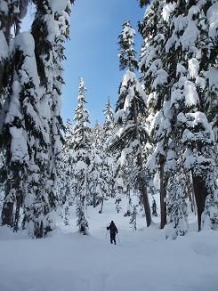
Ian skiing through the woods on the way to McCausland
Copyright © 2026 Gabriel Deal.