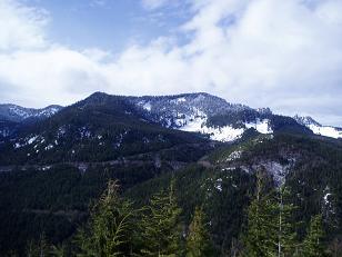
Haystack Mountain
I parked at the intersection of Road 62 and Road 6221. Road 6221 is
gated, otherwise I would have been able to drive on this road quite a
ways. I strapped my skis to my pack and headed up Road 6221.
The road passes through a lot of clear cut, which makes for good views
of Mount Persis, Gunn Peak, Ten Four Mountain, and the Skykomish
Valley. The road is clear all the way to the end, in summer it would
probably be an easy mountain bike ride. In winter it turned out to be
an easy ski on a thin snowpack.
The road ends on the NW side of Haystack Mountain, from here the
route to the summit is a short scramble through salal and sparse young
hemlocks. The the trees on the top of the logged-out summit are still
small enough to leave a 360 degree view, and the view is surprisingly
nice. Gunn Peak, Mount Baring, Mount Persis, Ten Four Mountain, Mount
Pilchuck, and Mount Stickney were all visible.
Elevation gain:
1,120 feet
Trip type:
cross-country ski
Car-to-car:
3 hours 49 minutes
-
1 hour 31 minutes
driving there
from
Lower Queen Anne
to
Intersection of Road 62 and Road 6221
-
1 hour 40 minutes
ascending
from
Intersection of Road 62 and Road 6221
to
end of road
-
11 minutes
ascending
from
end of road
to
summit of Haystack Mountain
-
33 minutes
ascending
from
summit of Haystack Mountain
to
summit of Haystack Mountain
-
1 hour 17 minutes
descending
from
summit of Haystack Mountain
to
Intersection of Road 62 and Road 6221
-
8 minutes
descending
from
Intersection of Road 62 and Road 6221
to
Intersection of Road 62 and Road 6221
-
1 hour 19 minutes
driving back
from
Intersection of Road 62 and Road 6221
to
Lower Queen Anne

Ten Four Mountain from Haystack Mountain
Copyright © 2024 Gabriel Deal.