Bessemer Mountain via SE ridge
Ian and I parked near the end of Bessemer's SE ridge on the Middle
Fork Road where the CCC Road-Trail merges with the Middle Fork Road.
We hiked up the CCC Road-Trail, took the first right off of CCC
Road-Trail, then took a left fork up a very rocky logging road. This
eventually led us to the SE ridge.
The ridge had some nice views of Mount Garfield, Preacher Mountain,
and the upper and lower Middle Fork Valleys. At a number of places we
had to drop to the left side of the ridge (never right) to avoid
obstructions. Finally we dropped left one final time to traverse a
steep field of ferns along the base of a massive gendarme, we regained
the ridge at around 4,600', dropped down a very steep brushy slope to
the right (north) side of the ridge, traversed below a sub-summit of
Bessemer, and ascended the gullies between the sub-summit and the
summit.
We roped up before ascending the final summit block, Ian led it with
slings over horns for protection. There was some real exposure here.
The summit was a satisfying jumble of rock with excellent 360 degree
views. There was a summit register with no more than half a dozen
entries since 2002. Despite taking over gallon of water, I drank my
last mouthful of water here.
We rappelled off the summit and returned to the ridge the same way we
arrived. Once on the ridge we traversed the basin to the logging road
that ends just east of and below the summit of South Bessemer
Mountain. Soon after the sun set and we walked the logging roads in
the dark. Despite the fact that I looked directly at it, I missed the
turn off to the CCC Road-Trail and we ended up taking the Bessemer
Connector trail to the Middle Fork Road and walking the road back to
our cars.
I wouldn't want to do this trip in wet weather, too much semi-exposed,
steep rock.
Elevation gain:
4,095 feet
Trip type:
basic alpine climb
In:
Middle Fork Snoqualmie Drainage, North Fork Snoqualmie Drainage
Car-to-car:
12 hours 59 minutes
-
7 hours 10 minutes
ascending
from
where CCC Road-Trail meets the Middle Fork Road
to
summit of Bessemer Mountain
-
1 hour 46 minutes
descending
from
summit of Bessemer Mountain
to
start of logging road S of South Bessemer Mountain
-
3 hours 15 minutes
descending
from
start of logging road S of South Bessemer Mountain
to
where CCC Road-Trail meets the Middle Fork Road
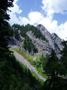
Bessemer Mountain from the SE ridge
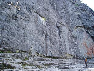
Rock wall SW of summit of Bessemer Mountain
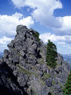
West side of Bessemer Mountain summit block
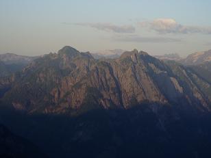
Sunset on Garfield Mountain
Copyright © 2026 Gabriel Deal.