Mount Phelps
We parked on Road 113 where a 4WD road forks off to Blackhawk Mine
(the mine is marked on USGS). Just before the 4WD road to the mine
ends a light bootpath heads to the right into a clearcut. In the
clearcut the path heads NNW at first then trends N, it splits and
rejoins itself many times, and is heavily marked by cairns and
flagging. The path eventually leads to a forest. The path ascends
a short distance into the forest, then traverses west to the start of
a sub-ridge that runs south of Mount Phelps (the sub-ridge is just west
of the "4200" on USGS). At the sub-ridge the trail forks, we followed
the fork that leads west to the 4,200'+ col between Mount Phelps and
Little Phelps. The trail peters out before reaching the col. At the
col we followed the ridge toward the summit, dropping to the N side of
the ridge for a while. Shortly before the summit the ridge meets a
section of small cliff bands above a small section of young hemlock.
We ascended a ramp running to the east above the hemlocks, and then
threaded our way to the summit. Fun.
The summit has a wonderful alpine feel and would probably have lots of
views in clear weather. The summit register only contained two
entries for this year.
On the descent we returned to the thicket of hemlocks below the cliff
bands and contoured south and east below the cliffs. We reached a
large talus field that runs down between the summit and a
dramatic-looking sub-peak of Phelps. We descended the talus field a
couple hundred vertical feet, then traversed SE to meet the top of
the sub-ridge (the one west of "4200"), then descended the sub-ridge to where
the bootpath forks.
We saw a black bear on the North Fork Road on the drive home.
Round-trip distance:
8 miles
Elevation gain:
2,919 feet
In:
North Fork Snoqualmie Drainage
Car-to-car:
6 hours 50 minutes
-
2 hours 12 minutes
ascending
from
trailhead
to
col between Little Phelps and Mount Phelps
-
1 hour 14 minutes
ascending
from
col between Little Phelps and Mount Phelps
to
summit of Mount Phelps
-
1 hour 29 minutes
descending
from
summit of Mount Phelps
to
fork in trail at start of ridgelet
-
1 hour 4 minutes
descending
from
fork in trail at start of ridgelet
to
trailhead
-
1 hour 50 minutes
driving back
from
trailhead
to
65th St Park & Ride
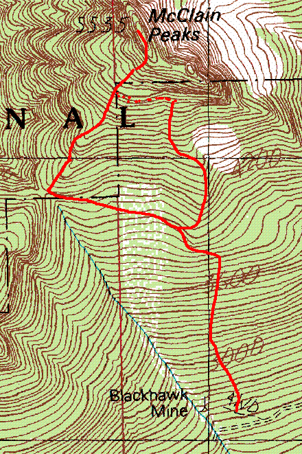
Mount Phelps route map
Copyright © 2026 Gabriel Deal.