Gunn Peak, try #1
Carla, Laurie, Tom and I parked on the Barclay Creek Road and followed
a slightly involved but well-flagged system of logging roads, trail,
and creek crossings to the Gunn Peak climber's trail. There is a
really good hand-drawn map of the way from Barclay Creek Road to the
start of the Gunn Peak trail at
http://cascadeclimbers.com/thr....
After leaving the logging road, the trail up to the basin is steep,
steep, steep and sometimes a scramble, but it is easy to follow and
cleared of brush.
After breaking out into the basin around 4,200 the trail becomes less
distinct (and often dissappears) and the flagging is bleached
and hard to spot. We followed the flagging up the west side of the
basin as it goes through sporadic brush and some small, scrambleable
cliff bands and eventually emerges into wonderful granite and heather
slopes below point 5,842 (Gunn Peak, SW Peak).
At the top of the basin there are three peaks, point 5,842, point
5,760+ (elevation not marked on the map), and point 5,760 (elevation
marked on map). The two 5,760's confused me, I thought the route in
Climbing Washington's Mountains was directing us to go over the pass between 5,842
and 5,760+ (the unmarked one). We took a look at the frozen slopes on
the other side of the pass and decided Gunn Peak was out for today and
we'd take the nearby SW Peak as our consolation peak.
Gunn Peak, SW Peak was an easy scramble except for a short section of
frozen snow. There was a cairn and a summit register at the top, the
register needs some new paper, it looked like the last party (March 6)
tore off a corner of their map to use in the register.
Tom's TR for this trip can be found at
http://www.nwhikers.net/forums....
Elevation gain:
3,660 feet
Car-to-car:
8 hours 50 minutes
-
4 hours 55 minutes
ascending
from
Barclay Creek Road
to
Gunn Peak, SW Peak summit
-
3 hours 2 minutes
descending
from
Gunn Peak, SW Peak summit
to
Barclay Creek Road
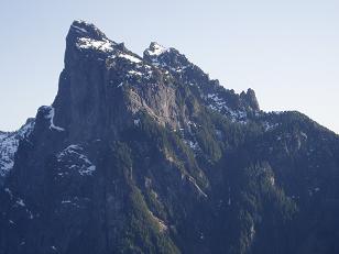
North side of Baring Mountain
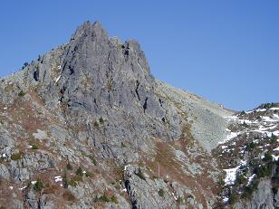
Gunn Peak, SE Peak
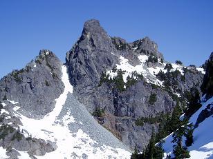
Gunn Peak from pass between Gunn Peak, SW Peak and point 5,760+
Copyright © 2026 Gabriel Deal.