Goat Mountain (Lake Philippa quad) loop (North Fork Snoqualmie)
Ian and I parked where the Lennox Creek Road (Road 57) is blocked by
berms right before Bear Creek. We walked across the bridge and
continued down the road for about 1.5 miles to where it turns sharply
left, here we followed an abandoned trail on the right side of the
road (shown on the Lake Philippa quad quad). The trail soon crosses Cougar
Creek via a downed tree. We often lost the trail, partly because of
the sporadic snow covering, and partly because nature is erasing the
trail. After a bit of brush bashing we came upon the remains of the
structure shown on the Lake Philippa quad quad.
At the structure we headed north up the side of the NE ridge of Goat
Mountain (Lake Philippa quad), this was brushy but we only ran into a
couple thick sections of brush. Once we reached the ridge-top we were
able to travel on it all the way to the summit of Goat Mountain (Lake
Philippa quad). The last couple hundred vertical feet of the ridge
before the summit had some nice granite which could be
scrambled/climbed or avoided.
The ridge and summit had excellent views. Mount Phelps in particular
made an early impression on us. Across the valley Bare Mountain had a
lot of red vegetation and looked like the trail was mostly snow-free.
Most of the peaks between Goat Mountain (Lake Philippa quad) and
Snoqualmie pass were visible, including Big Snow, Kaleetan Peak,
Garfield Mountain, Preacher Mountain, and Bessemer Mountain.
We descended via the basin to the north of Goat Mountain (Lake
Philippa quad). Around 3,400' we got on a small ridge running along
the east side of a stream in section 20. The forest on the ridge had
lot of brush, as I write this I have many thorns embedded in my body
and welts from devil's club. The old growth forest we descended
through had many incredibly beautiful sections full of deep moss,
ferns, yew, and ancient cedars. This forest was the best and the
worst part of the trip for me.
I forded Lennox Creek, Ian crossed on rocks I feared were too
slippery. After fighting the forest's brush, walking the road back to
the car was a relief.
Elevation gain:
3,655 feet
USGS quads:
Lake Philippa, Mount Phelps
In:
North Fork Snoqualmie Drainage
Car-to-car:
8 hours 25 minutes
-
1 hour
ascending
from
Bare Creek bridge
to
structure near Cougar Creek
-
4 hours 14 minutes
ascending
from
structure near Cougar Creek
to
Goat Mountain summit
-
2 hours 27 minutes
descending
from
Goat Mountain summit
to
back on Road 57
-
28 minutes
descending
from
back on Road 57
to
Bare Creek bridge
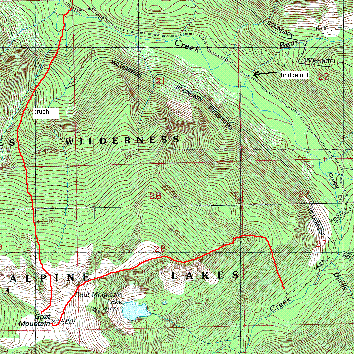
Goat Mountain loop map
-from-5,000'-on-NE-ridg.jpg)
Goat Mountain (Lake Philippa quad) from 5,000' on NE ridge
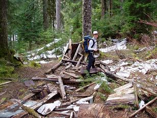
Structure at end of abandoned Cougar Creek trail
Copyright © 2026 Gabriel Deal.