Loch Katrine and the ridge above
I parked at the intersection of Road 29200 and the North Fork County
Road and hiked up Road 29200. Soon after crossing a concrete bridge I
went left (to the right is Lake Philippa). My Green Trails and USGS
maps both show the left fork of the road as a dead-end, but it
connects up to the logging road that leads to Loch Katrine. The road
gets occasional views of Little Phelps and Mount Phelps before it
reaches the lake. After passing Loch Katrine the road opens up more
and the views slowly expand to include Goat Mountain, Bare Mountain,
Lennox Mountain, and a couple bird's eye views of Loch Katrine. The
road ends on a sharp ridge that leads to Twin Peaks, at the end of the
road there is a lunch spot on a local high point of the ridge with 360
degree views.
Elevation gain:
2,540 feet
USGS quads:
Devil's Slide, Mount Phelps
In:
Alpine Lakes Wilderness, North Fork Snoqualmie Drainage
Car-to-car:
6 hours 27 minutes
-
1 hour 25 minutes
driving there
from
Lower Queen Anne
to
Loch Katrine trailhead
-
2 hours 8 minutes
ascending
from
Loch Katrine trailhead
to
Loch Katrine
-
1 hour 31 minutes
ascending
from
Loch Katrine
to
top of logging road
-
1 hour 56 minutes
descending
from
top of logging road
to
Loch Katrine trailhead
-from-logging-road-abov.jpg)
Goat Mountain (Lake Philippa quad) from logging road above
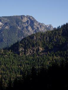
Little Phelps from logging road below Loch Katrine
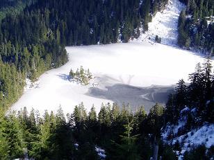
Loch Katrine from logging road
Copyright © 2026 Gabriel Deal.